Solo pedestrian jaunts during the past couple of years have exposed me to some formerly-invisible aspects of this planet, both natural and man-made. Walks and jogs have led me beside streams and around lakes, up hills and down valleys, through tunnels and over bridges, behind industrial parks and next to a host of residential structures.
But until now I haven't tried to map out the major long routes that I've explored. When I did recently, I was happily surprised to see a loose network taking shape, splattered across the landscape for a dozen miles around my home base — the beginnings of a suburban spiderweb, spun by a drunken arachnid plodder with a bias toward byways through woods and alongside flowing water.
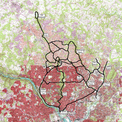
So to complement the left-brain textual descriptions posted earlier and elsewhere, here's a topographic thumbnail map (updated on 1 Jan 2005 to include runs of 2004):
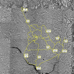
... and an aerial photomontage to the same scale (likewise updated on 1 Jan 2005):
Click for more detailed images (several hundred kB each). North is up and the paths shown are approximate. Marathons or other races aren't included except where their courses happen to have overlapped my fun runs. The river cutting across the southwest corner of the pictures is the Potomac. Each map is about 20 miles square. The yellow dot at the center is chez ^z.
Now, to fill in some of those gaps between the threads ...
(Many thanks to Keith Zimmermann for aerial and topographic snapshots of my extended neighborhood. See also WalkAbout (9 Mar 2002), RockCreekTrail (31 Mar 2002), InvisibleWeb (8 Dec 2002), AnacostiaTributaries (28 Jan 2003), CapitalCrescentCoordinates (5 May 2003), ForestPrimevalPedestrian (9 May 2003), ExpandingUniverse (26 Jun 2003), FifteenLeagueLeyLines (1 Jan 2005), ...)
TopicRunning - TopicPersonalHistory - 2003-11-23
(correlates: StreetSongs, BirdySunset, GoodBeyondHope, ...)

