The 27th Marine Corps Marathon was my first experience in running beyond 20 miles. It went well; see Bless the Leathernecks (28 Oct 2002) for a summary story, and PleasantSurprises (8 Aug 2002) for a few words on the virtue of setting modest goals.
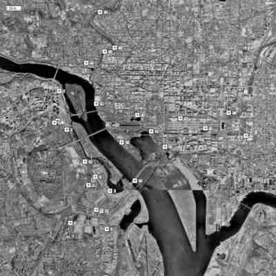
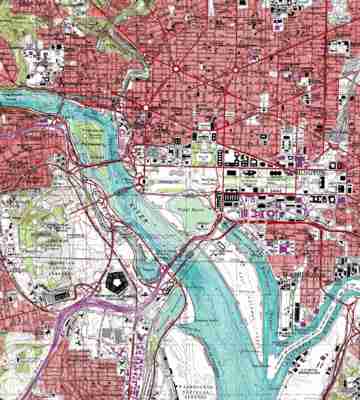
But for those who want less fuzzy humanity and more quantitative ammunition for their analyses, consider please the Global Positioning System (GPS) coordinates that I captured as my brother and I jogged along the course. (Click on the thumbnail to see the full image as produced by Keith Zimmermann.)
an aerial photo of the downtown Washington DC area with connect-the-dots marathon mile markers (but missing #7 and #8, alas; see below) — ~400 kb
a USGS topographic map of the same data, showing contour lines and labeled features — ~2 MB
And for the true quants in the audience, behold the raw lat/lon data, accompanied by timing information recorded on my stopwatch as we ran, plus a few contextual remarks:
| Mile | Latitude | Longitude | Time | Pace | Comments |
|---|---|---|---|---|---|
| 00 | 38:53:16 | 77:03:58 | - | - | starting line |
| 01 | 38:52:32 | 77:03:22 | 0:09:48 | 09:48 | swept away by early enthusiasm and adrenalin |
| 02 | 38:51:43 | 77:03:07 | 0:20:11 | 10:23 | settling down to a saner pace: Keith's schedule of 1 minute walking per 4 minutes of running for the first half of the course |
| 03 | 38:51:48 | 77:03:51 | 0:30:42 | 10:31 | jogging past the shopping centers and apartment complexes of Arlington, following the route KZ & I had driven a few days earlier in our preliminary reconnaissance |
| 04 | 38:52:01 | 77:03:20 | 0:41:00 | 10:18 | Pentagon south parking lot |
| 05 | 38:52:24 | 77:03:30 | 0:51:40 | 10:40 | northwestern side of the Pentagon, near the 11 Sep 2001 terrorist attack |
| 06 | 38:52:19 | 77:03:04 | 1:01:48 | 10:08 | approaching the 10km mark where our official time was recorded as 1:03:49 |
| 07 | - | - | - | - | no mile 7 marker seen (I am told it was hidden by the crowds) |
| 08 | - | - | - | - | no mile 8 marker seen |
| 09 | 38:53:52 | 77:04:08 | 1:32:46 | - | approaching the Key Bridge from Rosslyn to Georgetown |
| 10 | 38:54:19 | 77:03:36 | 1:43:36 | 10:50 | on the bumpy pavement and slippery steel plates of M Street |
| 11 | 38:54:34 | 77:03:02 | 1:54:18 | 10:42 | in Rock Creek, parallel to the path that I've sporadically jogged between the Levine School of Music and the Kennedy Center over the past few months |
| 12 | 38:55:07 | 77:03:21 | 2:05:01 | 10:43 | near the turnaround point (and out of earshot of the bagpipers who played vigorously further south along Rock Creek Parkway) |
| 13 | 38:54:30 | 77:03:14 | 2:15:53 | 10:52 | confession: we sprinted a bit as we neared the 13.1 mile half marathon sensor pad, where our time was officially logged as 2:16:56 |
| 14 | 38:53:41 | 77:03:23 | 2:26:57 | 11:04 | by the Kennedy Center and the Potomac |
| 15 | 38:53:31 | 77:02:33 | 2:37:40 | 10:43 | past the Lincoln Memorial, the Einstein statue at the National Academy of Sciences, the Vietnam Veterans Memorial, etc. |
| 16 | 38:53:29 | 77:01:41 | 2:48:29 | 10:49 | after viewing the White House and the Washington Monument we cut here onto the Mall proper, by the Smithsonian museums of American History and Natural History |
| 17 | 38:53:35 | 77:00:43 | 3:00:08 | 11:39 | past the National Galleries of Art and turning northeast toward Union Station |
| 18 | 38:53:14 | 77:00:22 | 3:11:49 | 11:41 | just in front of the Library of Congress on the eastern side of the Capitol |
| 19 | 38:53:20 | 77:01:11 | 3:23:34 | 11:45 | hooking into the south side of the Mall near the Air & Space Museum, the Hirschorn, the Freer, and other art galleries |
| 20 | 38:53:16 | 77:02:16 | 3:35:31 | 11:57 | back to the Washington Monument |
| 21 | 38:53:05 | 77:02:51 | 3:47:38 | 12:07 | curving down to the river again near the Lincoln Memorial |
| 22 | 38:53:02 | 77:01:59 | 3:59:57 | 12:19 | on the approach to the 14th Street Bridge, near the unofficial free beer distribution point |
| 23 | 38:52:29 | 77:02:34 | 4:11:32 | 11:35 | crossing the Potomac again, on a bridge that seemed to be mostly uphill |
| 24 | 38:52:00 | 77:03:14 | 4:23:42 | 12:10 | a final view of the Pentagon |
| 25 | 38:52:46 | 77:03:35 | 4:37:15 | 13:33 | commencing a long climb up toward the end of the race, roadsides packed with cheering spectators |
| 26 | 38:53:24 | 77:04:09 | 4:50:13 | 12:58 | almost there, but first a final arc around the Iwo Jima Memorial (this is the Marine Corps Marathon, after all) |
| 26.2 | 38:53:22 | 77:04:13 | 4:53:00 | - | the finish line ("Rejoice — we conquer!") |
(All latitudes are North, all longitudes are West; datum is WGS84. Note that this table may contain errors from both measurement and transcription. See also GlobalPositioningSystemRuns (16 Feb 2002), GettysburgCoordinates (27 Feb 2002), RichardsonianExtrapolation (18 Apr 2002), CoordinateCollection (19 May 2002), RockCreekTrail (31 May 2002), Boston Public Library (20 Jun 2002), MarathonCoordinates (3 Oct 2002), ...)
TopicScience - TopicPersonalHistory - TopicRunning - 2002-11-01
Bless you! I am not alone in Mapping My World!
I have carried a GPS everywhjere I have gone in the last few years (and that has been a lot of "wheres").
I have carried these data back to add to a photojournalist record of where I have been and a few of these have been put on satellite images of the topo to give GIS (see Seven Points).
I have also heard about a piece of software that does it without the labor intensivity, called the Trimble (see attached.)
And, just for fun, I add my fuzzier huamn notes onthe MCM-27, hardly my first marathon, but as enjoyable as any I have done!
Cheers!
GWG
PS My "attachments" will be tacked on in direct email to you
(correlates: RockCreekTrail, 2007-09-08 - Mall Rats, MarathonCoordinates, ...)

